Wadi Rum
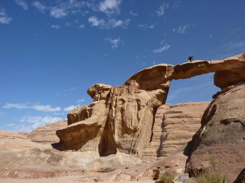
Wadi Rum also known as The Valley of the is a valley cut into the sandstone and granite rock in southern Jordan 60 km (37 mi) to the east of Aqaba; it is the largest wadi in Jordan. The name Rum most likely comes from an Aramaic root meaning 'high' or 'elevated'. To reflect its proper Arabic pronunciation, archaeologists transcribe it as Wadi Ramm.
Wadi Rum has been inhabited by many human cultures since prehistoric times, with many cultures–including the Nabateans–leaving their mark in the form of rock paintings, graffiti, and temples.
In the West, Wadi Rum may be best known for its connection with British officer T. E. Lawrence, who passed through several times during the Arab Revolt of 1917–18. In the 1980s one of the rock formations in Wadi Rum was named "The Seven Pillars of Wisdom" after Lawrence's book penned in the aftermath of the war, though the 'Seven Pillars' referred to in the book have no connection with Rum.
Petra Jordan (Rose City)
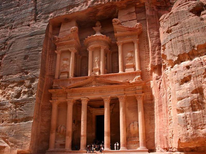
Petra Jordan
Petra Jordan a historical and archaeological city in the southern Jordanian governorate of Ma'an that is famous for its rock-cut architecture and water conduit system. Another name for Petra is the Rose City due to the color of the stone out of which it is carved.
Established possibly as early as 312 BCE as the capital city of the Nabataeans, it is a symbol of Jordan, as well as Jordan's most-visited tourist attraction.
It lies on the slope of Jebel al-Madhbah (identified by some as the biblical Mount Hor) in a basin among the mountains which form the eastern flank of Arabah (Wadi Araba), the large valley running from the Dead Sea to the Gulf of Aqaba. Petra has been a UNESCO World Heritage Site since 1985.
Petra Jordan site remained unknown to the Western world until 1812, when it was introduced by Swiss explorer Johann Ludwig Burckhardt. It was described as "a rose-red city half as old as time" in a Newdigate Prize-winning poem by John William Burgon. UNESCO has described it as "one of the most precious cultural properties of man's cultural heritage".. Petra was chosen by the Smithsonian Magazine as one of the "28 Places to See Before You Die.
Dead Sea
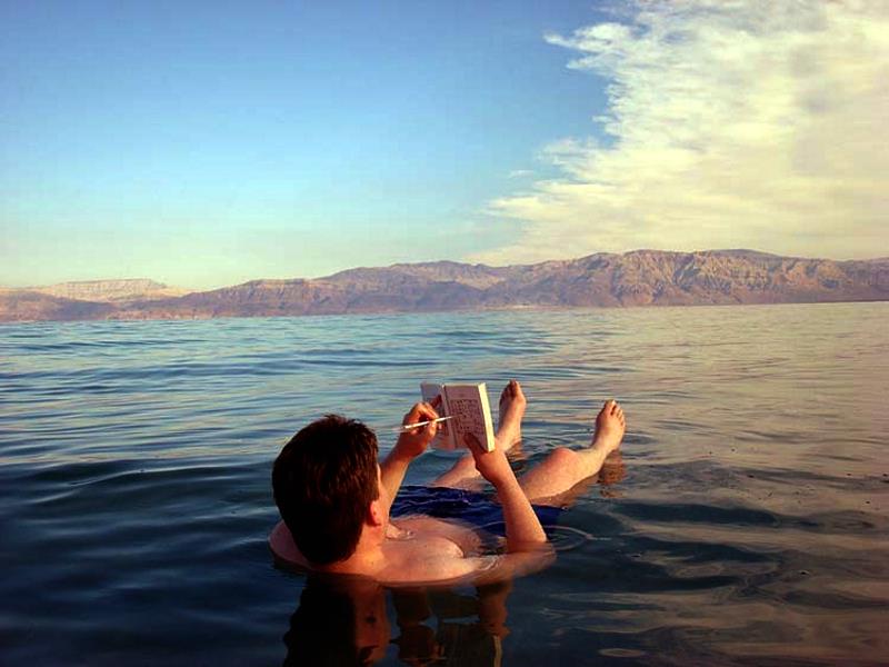
The Dead Sea : is a salt lake bordering Jordan to the east, and Palestine and Israel to the west. Its surface and shores are 427 metres (1,401 ft) below sea level,[3] Earth's lowest elevation on land. The Dead Sea is 306 m (1,004 ft) deep, the deepest hypersaline lake in the world. With 34.2% salinity (in 2011), it is also one of the world's saltiest bodies of water, though Lake Vanda in Antarctica (35%), Lake Assal (Djibouti) (34.8%), Lagoon Garabogazköl in the Caspian Sea (up to 35%) and some hypersaline ponds and lakes of the McMurdo Dry Valleys in Antarctica (such as Don Juan Pond (44%)) have reported higher salinities. It is 9.6 times as salty as the ocean.[5] This salinity makes for a harsh environment in which animals cannot flourish, hence its name. The Dead Sea is 50 kilometres (31 mi) long and 15 kilometres (9 mi) wide at its widest point .It lies in the Jordan Rift Valley, and its main tributary is the Jordan River.
The Dead Sea has attracted visitors from around the Mediterranean basin for thousands of years. Biblically, it was a place of refuge for King David. It was one of the world's first health resorts (for Herod the Great), and it has been the supplier of a wide variety of products, from balms for Egyptian mummification to potash for fertilizers. People also use the salt and the minerals from the Dead Sea to create cosmetics and herbal sachets.
Dead Sea seawater has a density of 1.240 kg/L, which makes swimming similar to floating.
Aqaba
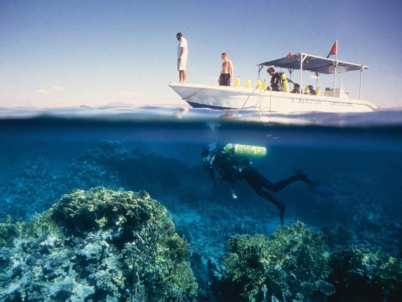
Aqaba is a Jordanian coastal city situated at the northeastern tip of the Red Sea. Aqaba is the largest city on the Gulf of Aqaba and Jordan's only coastal city.
The city of Aqaba is the capital of Aqaba Governorate. Aqaba is one of the major tourist attractions in Jordan, and famous for its warm water and rich marine life. It is best known today as a seaside and diving resort and also as a home for Jordan's mega projects.
However, industrial and commercial activities remain important, due to the strategic location of the city as the country's only seaport.
Madaba & Mount Nebo
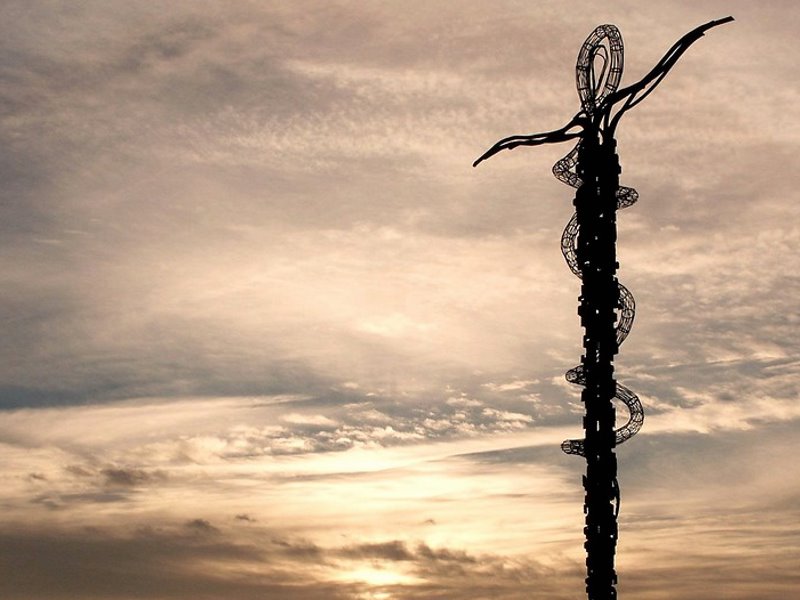
Madaba is the capital city of Madaba Governorate in central Jordan, which has a population of about 60,000. It is best known for its Byzantine and Umayyad mosaics, especially a large Byzantine-era mosaic map of The Holy Land. Madaba is located 30 kilometres (19 miles) south-west of the capital Amman.
The Catholic Church's list of titular sees uses the spelling "Medaba", traditional in reference to the ancient bishopric centred on this city, while at the same time referring to the modern city as 'Madaba.
Mount Nebo : is an elevated ridge in Jordan, approximately 817 meters (2680 feet) above sea level, mentioned in the Bible as the place where Moses was granted a view of the Promised Land that he would never enter. The view from the summit provides a panorama of the Holy Land and, to the north, a more limited one of the valley of the River Jordan.
The West Bank city of Jericho is usually visible from the summit, as is Jerusalem on a very clear day.
Baptism Site & Jordan River
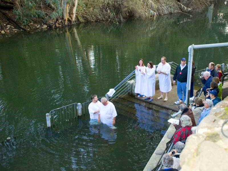
The Baptism of Jesus marks the beginning of his public ministry 51 KM from Amman to Jordan River . This event is recorded in the canonical gospels of Matthew, Mark and Luke. John's gospel does not directly describe Jesus' baptism.
Most modern scholars view the fact that Jesus was baptized by John the Baptist as an historical event to which a high degree of certainty can be assigned. Along with the crucifixion of Jesus, most scholars view it as one of the two historically certain facts about him, and often use it as the starting points for the study of the historical Jesus.
The baptism is one of the five major milestones in the gospel narrative of the life of Jesus, the others being the Transfiguration, Crucifixion, Resurrection, and Ascension. Most Christian denominations view the baptism of Jesus as an important event and a basis for the Christian rite of baptism (see also Acts 19:1-7). In Eastern Christianity, Jesus' baptism is commemorated on 6 January, the feast of Epiphany. In the Roman Catholic Church, the Anglican Communion, the Lutheran Churches and some other Western denominations, it is recalled on a day within the following week, the feast of the baptism of the Lord. In Roman Catholicism, the baptism of Jesus is one of the Luminous Mysteries sometimes added to the Rosary. It is a Trinitarian feast in the Eastern Orthodox Churches.
The main sites in the location :
- Elijah's Hill
- Cave Church
- Rhotorius Monastery
- The Pools
- Northern Church
- The Bethany Saphsaphas
- Water System
- Prayer Hall
- The Church of the Arch
- Western Church
- Ancient Pool
- Cave Cells
- John the Baptist Spring
- Laura
- Saint Mary the Egyptian
- The Pilgrims Station
- The Place where Jesus was baptized
Umm Qais
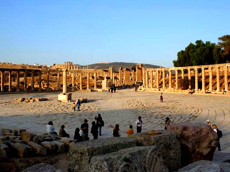
Umm Qais is a town in northern Jordan near the site of the ancient town of Gadara. It is situated in the extreme north-west of the country, where the borders of Jordan, Israel and Syria meet, perched on a hilltop (378 metres above sea level), overlooking the sea of Tiberias, the Golan heights and the Yarmuk gorge. Umm Qais is in Jordan's Irbid Governorate and belongs to the Bani Kinanah Department.
Al Karak
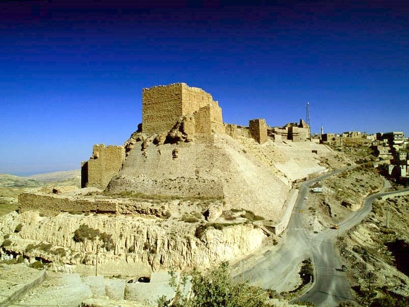
Al Karak also known as Kerak, is a city in Jordan known for its crusader castle, the Kerak Castle. The castle is one of the three largest castles in the region, the other two being in Syria. Karak is the capital city of the Karak Governorate.
Karak, once a kingdom, lies 140 kilometres (87 mi) to the south of Amman on the King's Highway. An ancient Crusader stronghold, it is situated on a hilltop about 1,000 metres (3,300 ft) above sea level and is surrounded on three sides by a valley. Karak has a view of the Dead Sea.
A city of about 20,000 people has been built up around the castle and it has buildings from 19th century Ottoman period. The town is built on a triangular plateau, with the castle at its narrow southern tip, but it is undoubtedly Kerak Castle which dominates.
Jerash
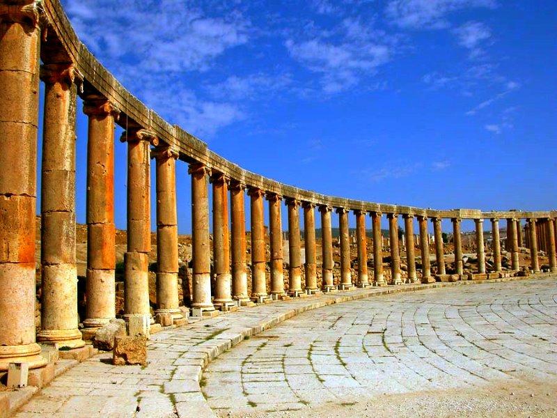
Jerash, the Gerasa of Antiquity is the capital and largest city of Jerash Governorate, which is situated in the north of Jordan, 48 kilometres (30 mi) north of the capital Amman towards Syria. Jerash Governorate's geographical features vary from cold mountains to fertile valleys from 250 to 300 metres (820 to 980 ft) above sea level, suitable for growing a wide variety of crops.
In the latter Ottoman period, the city of Jerash's name was abandoned and changed to Sakib, yet this was not a permanent development, as the name "Jerash" reappears in Ottoman tax registers by the end of 16th century.
A strong earthquake in 749 AD destroyed large parts of Jerash, while subsequent earthquakes along with the wars and turmoil contributed to additional destruction. Its destruction and ruins remained buried in the soil for hundreds of years until they were discovered by German Orientalist Ulrich Jasper Seetzen in 1806. He began excavation and a return to life of the current Jerash by inhabitants of older villages. 70 years later, this was followed by the Muslim community, Circassians, who emigrated to Jordan from the Caucasus in 1878 after the Ottoman-Russian war.
Subsequently a large community of people from Syria came to the area at the beginning of the 20th century.
Al Shoubak Castle
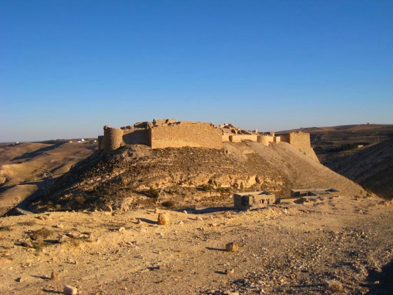
Montreal (Crusader castle)
Montreal is a Crusader castle on the eastern side of the Arabah, perched on the side of a rocky, conical mountain, looking out over fruit trees below. The ruins, called Shoubak or Shawbak in Arabic, are located in modern town of Shoubak in Jordan.
The castle was built in 1115 by Baldwin I of Jerusalem during his expedition to the area where he captured Aqaba on the Red Sea in 1116. Originally called 'Krak de Montreal' or 'Mons Regalis', it was named in honour of the king's own contribution to its construction (Mont Royal). It was strategically located on a hill on the plain of Edom, along the pilgrimage and caravan routes from Syria to Arabia. This allowed Baldwin to control the commerce of the area, as pilgrims and merchants needed permission to travel past it. It was surrounded by relatively fertile land, and two cisterns were carved into the hill, with a long, steep staircase leading to springs within the hill itself.
It remained property of the royal family of the Kingdom of Jerusalem until 1142, when it became part of the Lordship of Oultrejordain. At the same time the centre of the Lordship was moved to Kerak, a stronger fortress to the north of Montreal. Along with Kerak, the castle owed sixty knights to the kingdom. It was held by Philip de Milly, and then passed to Raynald of Châtillon when he married Stephanie de Milly. Raynald used the castle to attack the rich caravans that had previously been allowed to pass unharmed. He also built ships there, then transported them overland to the Red Sea, planning to attack Mecca itself. This was intolerable to the Ayyubid sultan Saladin, who invaded the kingdom in 1187. After capturing Jerusalem, later in the year he besieged Montreal. During the siege the defenders are said to have sold their wives and children for food, and to have gone blind from "lack of salt." Because of the hill Saladin was unable to use siege engines, but after almost two years the castle finally fell to his troops in May 1189, after which the defenders' families were returned to them. The Mameluks later captured and rebuilt it.
Ajlun
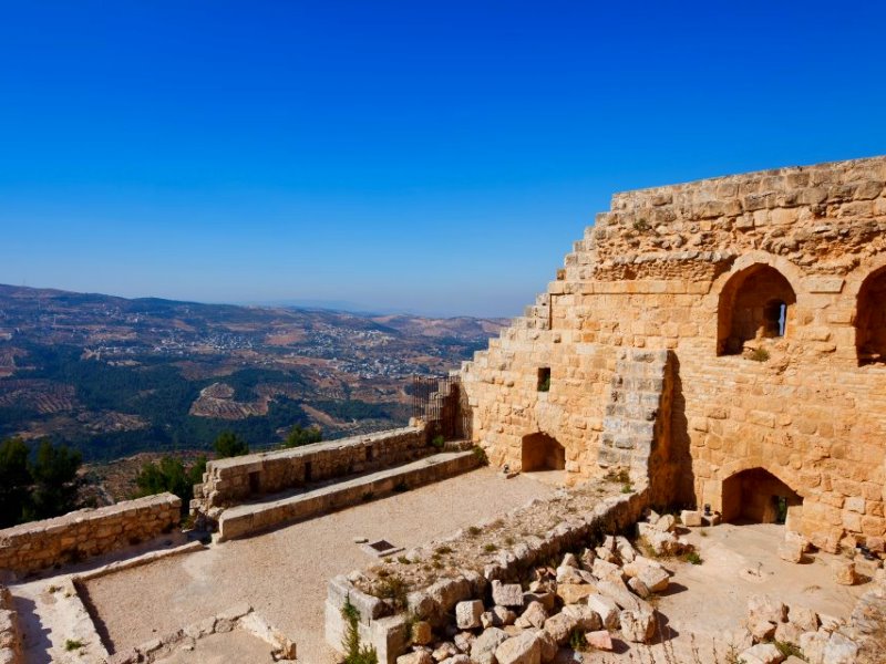
Ajlun The fortress was built by Izz al-Din Usama, a commander and nephew of Salah ad-Din al-Ayyubi (Saladin), in AD 1184-1185. The fortress is considered one of the very few built to protect the country against Crusader attacks from Karak in the south and Bisan in the west.
From its situation, the fortress dominated a wide stretch of the northern Jordan Valley, controlled the three main passages that led to it (Wadi Kufranjah, Wadi Rajeb and Wadi al-Yabes), and protected the communication routes between south Jordan and Syria. It was built to contain the progress of the Latin Kingdom of Transjordan and as a retort to the castle of Belvoir a few miles south of the lake of Tiberias. Another major objective of the fortress was to protect the development and control of the iron mines of Ajlun.
The original castle core had four corner towers. Arrow slits were incorporated in the thick walls and it was surrounded by a fosse averaging 16 meters (about 52 feet) in width and 12–15 meters (about 39–49 feet) in depth.
Dana Biosphere Reserve
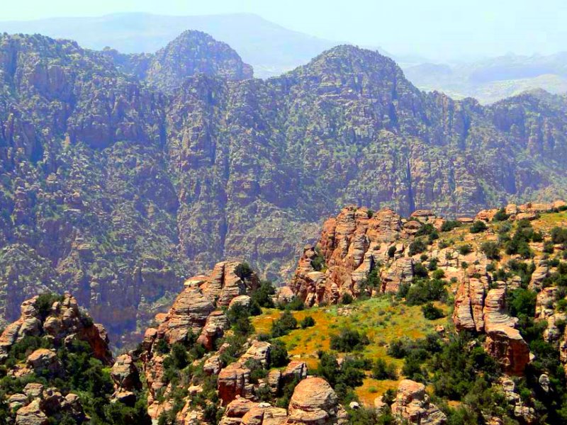
Established in 1989, Dana Biosphere Reserve is Jordan’s largest nature reserve, covering some 320 km2 of rugged and beautiful landscape along the face of the Great Rift Valley. It sweeps down in a series of mountain ridges, from the 1500m high plateau near Quadesiyya to the desert plains of Wadi Araba. The mountains are cut by many steep-sided wadis, often lined with a lush growth of trees and shrubs. Its geology is as varied as its landscape, switching from limestone to sandstone to granite.
Dana Biosphere Reserve is the only reserve in Jordan that includes the four different bio-geographical zones of the country; Mediterranean, Irano-Turanian, Saharo Arabian and Sudanian penetration. As such, it is the most diverse nature reserve in the country in terms of habitats and species, hosting several vegetation types, including the Phoenician Juniper, evergreen oak, sand dunes, acacia, and rocky sudanian, among others. It is also home to the southernmost remaining forest community of Cypress Cupressus simpervirens.
More than 800 plant species can be found within the reserve, three of which have only ever been recorded in Dana and nowhere else in the world. Their Latin names include the word ‘Dana’ in them.
Wadi Mujib
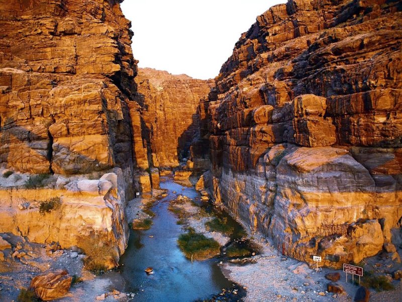
Wadi Mujib, historically known as Arnon, is a gorge in Jordan which enters the Dead Sea at 410 metres (1,350 ft) below sea level. The Mujib Reserve of Wadi Mujib is located in the mountainous landscape to the east of the Dead Sea, approximately 90 km south of Amman. The 220-square-kilometre (85 sq mi) reserve was created in 1987 by the Royal Society for the Conservation of Nature and is regionally and internationally important, particularly for the bird life that the reserve supports. It extends to the Kerak and Madaba mountains to the north and south, reaching 900 metres (3,000 ft) above sea level in some places. This 1,300-metre (4,300 ft) variation in elevation, combined with the valley's year round water flow from seven tributaries, means that Wadi Mujib enjoys a magnificent biodiversity that is still being explored and documented today. Over 300 species of plants, 10 species of carnivores and numerous species of permanent and migratory birds have been recorded until this date. Some of the remote mountain and valley areas are difficult to reach, and thus offer safe havens for rare species of cats, goats and other mountain animals.


